


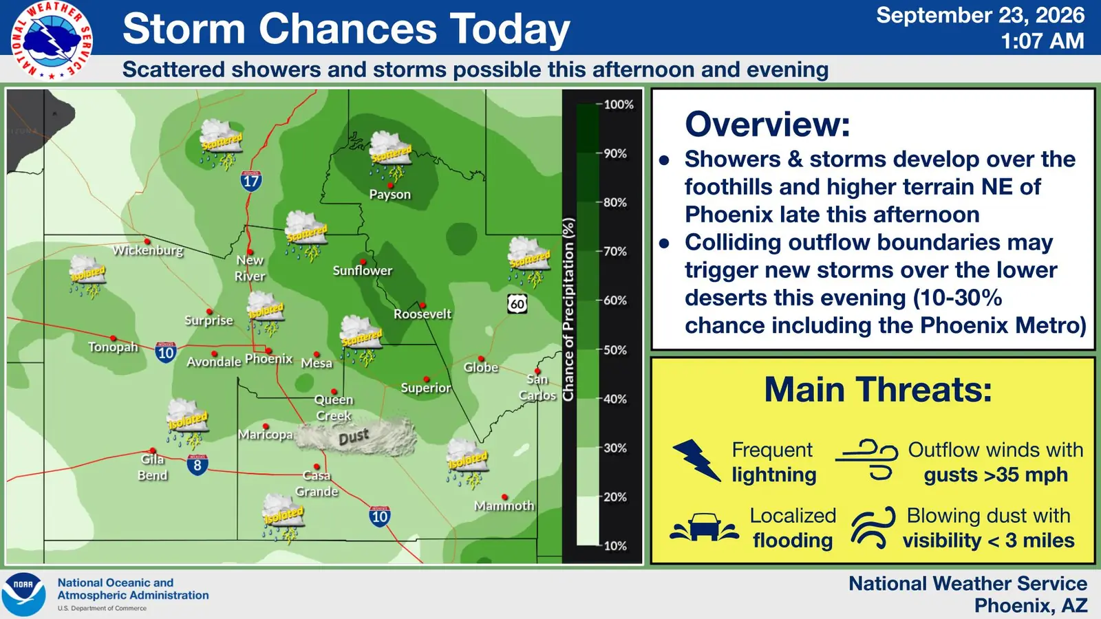
Updated at 5:35 a.m. Wednesday, Sept. 23, 2026: West Valley residents could encounter thunderstorms, gusty outflow winds, blowing dust and brief heavy rain Wednesday afternoon and evening, according to the National Weather Service in Phoenix. No weather watch or warning was in effect for Surprise or Buckeye at that time.
The weather service’s early-Wednesday outlook places Surprise, Tonopah and much of the western Phoenix metro in an area where isolated storms are possible. The most widespread activity is expected over higher terrain northeast of Phoenix, but forecasters said colliding outflow boundaries could generate additional storms over the lower deserts later in the day.
For the Phoenix metro, the weather service estimated a 10% to 30% chance of storms. Most locations may receive no rain, but conditions can change quickly where a storm or outflow boundary develops.
What the West Valley forecast shows
The NWS point forecast for Surprise calls for a high near 99 degrees Wednesday, with breezy conditions during the day. The chance of showers and thunderstorms rises to 30% Wednesday night, mainly before 10 p.m., with wind gusts as high as 20 mph.
For the Buckeye and Avondale area, the zone forecast also gives a 30% chance of evening showers and thunderstorms. A point forecast near Buckeye indicates that patchy blowing dust could develop between about 8 and 11 p.m.
The NWS weather graphic identifies the main potential hazards as frequent lightning, outflow gusts above 35 mph, localized flooding and blowing dust that could reduce visibility below three miles. Those hazards are possible within or near storms and do not mean every West Valley community will experience them.
What residents should watch for
Drivers should be prepared for abrupt visibility reductions if an outflow boundary lifts dust across open desert or major roads such as Interstate 10, Loop 303, U.S. 60 or State Route 85. Avoid entering a flooded roadway, even when water appears shallow.
Outdoor plans may also be affected by lightning before rain reaches a location. The National Weather Service recommends moving indoors when thunder is heard. Its flood-safety guidance advises drivers not to cross water covering a road.
Residents can monitor the NWS Phoenix forecast page and local emergency alerts through Wednesday evening.


Comments
Join the conversation. Keep comments relevant, civil and focused on the story.